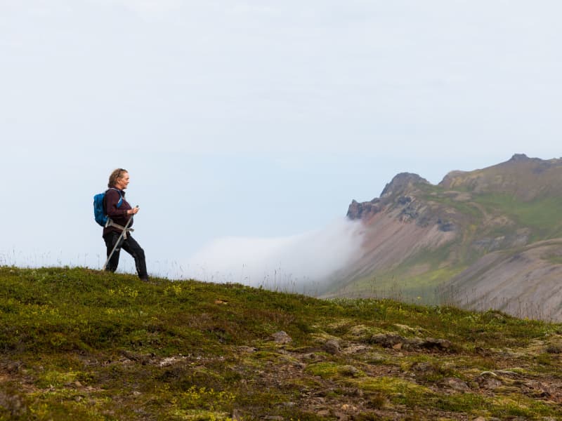
The Austurland highlands is an amazing area, interesting to explore. There are many things to see, including majestic mountains, impressive waterfalls and canyons, wilderness, wildlife and old farms.
Bear in mind, that the highland roads are just open during summer and it is necessary to monitor the weather forecast and road conditions closely when planning a trip to the highlands.
Norðurdalur - Mountain biking
The start of the trail is at the Ufsárlón reservoir, east of the bridge over the Jökulsá í Fljótsdal glacial river. Please close the gate after you. The trail leads down the valley along the glacial river along the fence and stops at Glúmstaðarsel. From there you can cross the river with the cable car or keep on going with the road leading out the valley to you final destination.
The trail is set at a medium difficulty. there are short wetlands areas, but they are not very difficult to pass. The path itself is not dangerous, but we ask people to take extra care close to the cliffs.
More information about the mountain biking trail in Norðurdalur can be found here.
View
Vatnajökull National Park
Vatnajökull national park established in 2008, covers around 14,5% of Iceland. It covers the entire Vatnajökull glacier, large areas in its vicinity and numerous municipalities. National parks are protected areas that are considered special because of their natural or historical significance. The uniqueness of Vatnajökull National Park lies mainly in the interplay between fire and ice.Among highlights of the east are Kverkfjöll, the home of Ice and fire, the oasis Hvannalindir, Snæfell the ancient volcano, where the reindeer roam and Eyjabakkar the celebrated home of the Pink-footed Goose.
View
Magnahellir
Drive north of Kárahnjúkastífla reservoir along a road (fit for SUV) on Lambafell to crossroads by Laugavellir. Drive down to a parking area by Dimmugljúfur canyons. There you will find a sign containing information and the trail running through Hafrahvammar canyon and Magnahellir cave where you will find the cylinder with the visitors’ log and stamp. The farmers in Eiríksstaðir used to keep their sheep in the slopes by Jökulsá river close to the cave called Magna cave which derives its name from the farmer named Magni who was the first one to keep his sheep there in winter.
Part of Hiking Treasures in Egilsstaðir Region
GPS : N64°99.252-W15°71.683
Powered by Wikiloc
View
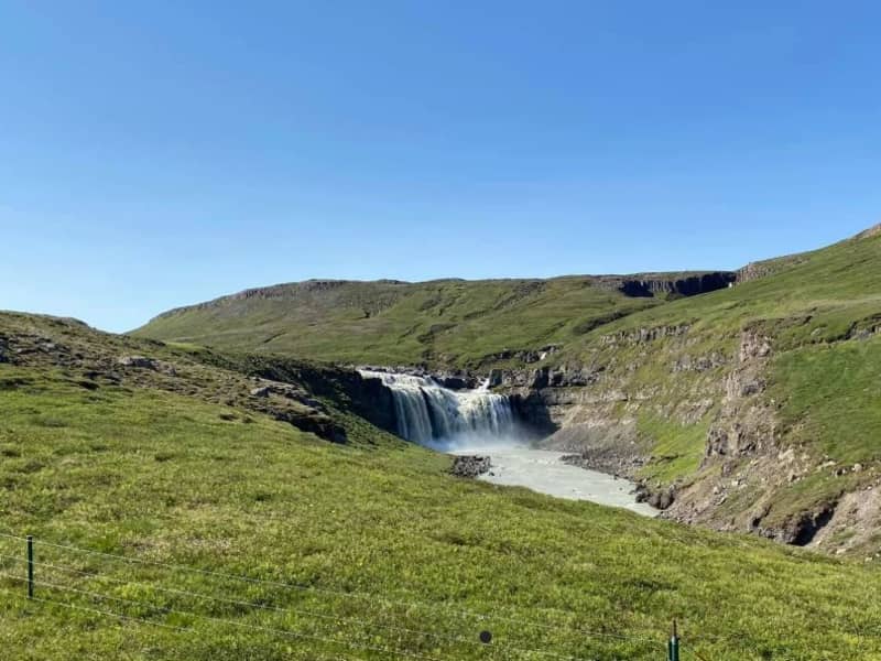
The Waterfall Circle
The Waterfall Circle is an 8 kilometers long hiking circle that starts and ends in Laugarfell. The trail takes you through a rugged and varied highland landscape and features five waterfalls, along with breathtaking views of Snæfell mountain and a dramatic canyon.
This beautiful hike is getting more and more popular among hikers and takes around 2–3 hours to complete, depending on conditions and pace. While it’s not overly difficult, there are a few steep and rocky sections, so sturdy footwear is recommended.
After the hike, you can soak your tired legs in Laugarfell’s natural hot spring. This trail is typically accessible from mid-June once snow has melted in the highlands.
GPX file of the track
Powered by Wikiloc
View
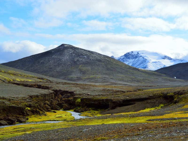
Sanddalur
Sanddalur is a beautiful valley that lies south of Snæfell. The valley is barren and breathtaking with green moss plains and peculiar rock formations that envelop the valley with a fairytale glow. To go to Sanddalur you need a four-wheel-drive car, but you can also walk there from road number 910 to Kárahnjúkar.
View
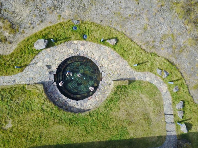
Laugarfell
Laugarfell is located in the eastern part of the Icelandic Highlands, a bit north from Mount Snæfell. There are only two km from the road that leads to Kárahnjúkar to the hostel and it is the only part of the road that is not paved. In the summer there is good access to Laugarfell in all kinds of vehicles.
Laugarfell offers accommodation for 28 people. Two natural pools are located in Laugarfell and according to old folk tales the water is known for its healing powers.
There are many interesting tracking paths around Laugarfell and a number of beautiful waterfalls. Additionally, one can expect to see reindeers wandering around the area of Laugarfell.
Laugarfell is open from the 1st of June to 30th of September.
View
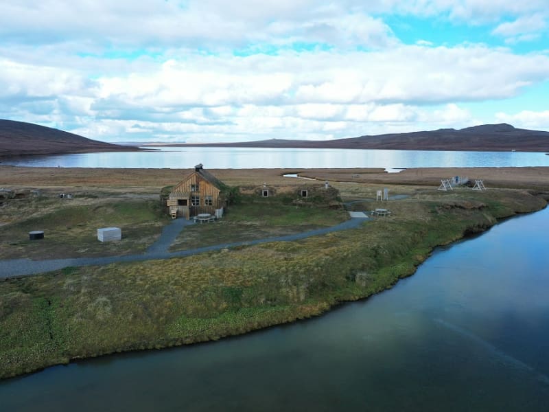
Sænautasel highland farm
Sænautasel on Jökuldalsheiði is a unique location by the tranquil mountain lake, Sænautavatn. Sænautasel is an old highland farmstead that was rebuilt in 1992 and has been welcoming visitors during the summer since then. At Sænautasel, you can learn about the conditions and struggles of those who lived in the highlands. Guided tours are offered around the farm, sharing stories about the people and farming practices at the highland farmsteads that were inhabited well into the 20th century. Light refreshments are available in a traditional style.
It is open every day in June-August.
From Sænautasel, it is a short distance to the magnificent natural rock formations Skessugarður slightly west on Jökuldalsheiði, and also close to Stuðlagil on Jökuldalur.
Settlement in Jökuldalsheiði began in the mid-19th century. The settlements in the highlands were partly built on the ruins of ancient farms and sheepfolds. The highlands are exceptionally beautiful in summer, making it hard to imagine how it was to live there year-round, including the harsh winters. The first farmstead built in the highlands during this period was Háreksstaðir in 1841. Over the next two decades, a total of 16 farmsteads were established in Jökuldalsheiði, the last one in 1862. The quality of the highland farms varied, and their periods of occupancy ranged from a single year at some to nearly a whole century at Sænautasel. The reasons for establishing these highland farms included overcrowding in the lowlands where all farms were occupied, and the development of urban areas and employment opportunities by the sea was still minimal. Therefore, people had few alternatives other than being laborers or tenants.
The farming conditions in the highlands were not entirely bad, although most places had heavy snow, as most farms were over 500 meters above sea level. Resources such as trout fishing in lakes, hunting for ptarmigan, geese, ducks, and swans, and grass harvesting were significant supplements. Some areas had excellent hayfields, at least in good years. Reindeer roamed the area, though their population was at a historical low around the turn of the 20th century. About 120 people lived in the highlands simultaneously at its peak. The eruption of Askja in 1875 greatly affected the highland settlements, causing a temporary abandonment of all farms except the northernmost ones. Many who left eventually emigrated to America. A few years later, some farms were reoccupied, and the settlement continued into the early decades of the 20th century. The last farm was abandoned in 1946.
Sænautasel was first established in 1843 and was inhabited until 1943, except for five years after the Askja eruption. It was the longest-inhabited farm in the highlands, occupied for a total of 95 years. Farming in the highlands under difficult conditions and great isolation has inspired Icelandic writers. Many fans of Halldór Kiljan Laxness know the story of Bjartur of Summerhouses in the novel *Independent People*. It describes the struggle of an independent crofter in a remote highland area. Many believe the story's inspiration came from Sænautasel, as Halldór stayed there in the 1920s. Highland farming was also a subject for writers Gunnar Gunnarsson and Jón Trausti.
Old legends said that sea cattle had been seen in Sænautavatn and even suggested that there were underwater tunnels from the lake to the sea that the sea cattle used.
View
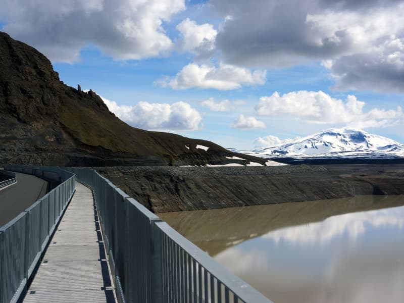
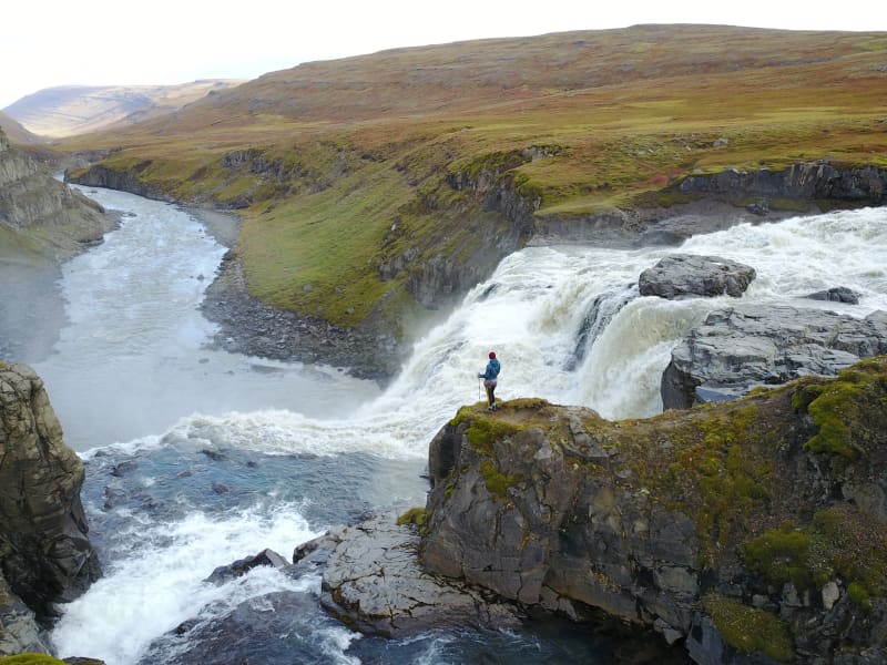
Kárahnjúkar
The Power Plant at Kárahnjúkar is the largest construction project in Icelandic history and the most significant electricity production in the country. The Kárahnjúkar Power Plant was built to produce energy for the aluminum plant at Reyðarfjörður.
A trip to Kárahnjúkar is an ideal road trip for the family. A paved road runs from Fljótsdalur to the Kárahnjúkar dam.
The Kárahnjúkar area is ideal for outdoor activities. It is fun to see the Kárahnjúkar Dam itself and the Hálslón Reservoir. When Hálslón fills up and overflows, the Hverfandi waterfall appears at the western end of the dam, where the water plunges about 100 meters into Hafrahvammahljúfur. The waterfall is mighty and can become more powerful than Dettifoss. There are also fun hiking trails in the area; for example, there is a great hiking trail along Hafrahvammagljúfur and to Magnahellir, but to get to the starting point of the marked hiking trail, you need a four-wheel-drive car.
View
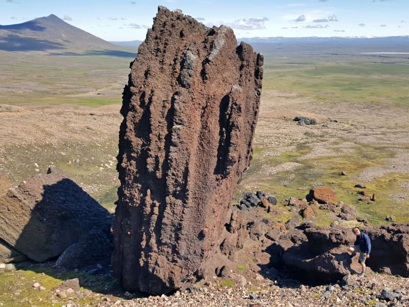
Skessugarður
Skessugarður - the Rampart of the Giantess is a natural phenomenon in East Iceland, which has been called one of the most amazing natural formations in the country. It was formed by an ice-age glacier, Brúarjökull. It is a large arch-shaped moraine and consists of massive boulders (porphyritic basalt) making up to a ca 300 meters long and ca 7 meters high natural wall. It lies from west to east. It marks the stagnation level of Brúarjökull at the end of the last glacial period.
After the stagnation of the glacier, a flood followed which washed this area clean of smaller rock leaving behind the big ones which makes this moraine unique as it lacks all smaller, finer sand particles and stones, or the glacial flour.
Skessugarður is located by the lake Grjótgarðsvatn was of Sænautasel turf house, on the other side of Mt. Snæfell. Turn left onto the old ring road (number 907, a gravel road) after you leave Sænautasel and drive for a couple of km. Then turn left onto a dirt road, which turns into a track until you reach Skessugarður after 2 km.
View

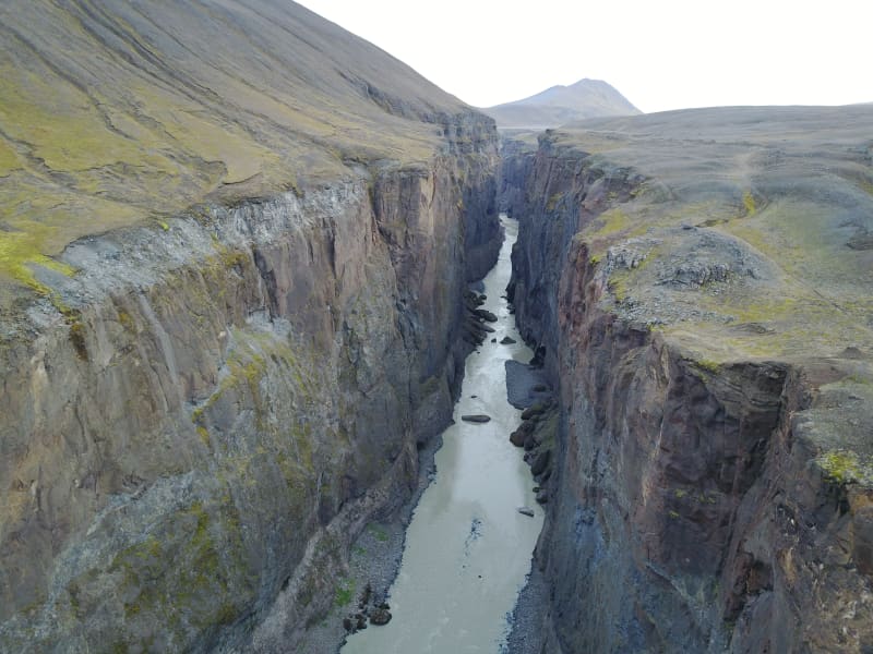
Hafrahvammagljufur
Hafrahvammagljúfur in Austurland is one of the largest and most magnificent gorges in Iceland. The gorge is about 200 meters from the bottom to the edge (where it is highest), and the canyon is about 8 kilometers long. There is a marked hiking trail along the gorge and down to Magnahellir. You need a four-wheel-drive car to drive to the trail's starting point, but you can see part of the gorge from Kárahjúkar dam, and you can get there by an average car.
View
Víknaslóðir
Víknaslóðir trails, sometimes also referred to as Trails of the Inlets is a vast net of well-marked and versatile hiking routes reaching from the village in Borgarfjörður Eystri to Loðmundarfjörður. Locals have through the years marked out and maintained numerous trails, making the area a rightfully called hiker's Paradise. They also publish a high-quality hiking map and operate comfortable hiking lodges with facilities in Breiðavík, Húsavík and Loðmundarfjörður, deserted inlets and fjord, south of Borgarfjörður Eystri.
The mountains come in all shapes and sizes and the variety of colors is stunning; everything from the black sand beaches to the pinkish orange hues of the mountain ridges. The trails wind themselves between isolated coves and fjords over colorful hills and through green valleys all the way down to the coast. Abandoned houses and ruins of ancient farms leave their mark on the surroundings.
Travellers can easily spend a few days in the area exploring and taking in the breathtaking views. Tourism companies in Borgarfjörður Eystri offer hikers all kinds of services related to their journey, whether it be tour planning, guidance or transport.
View
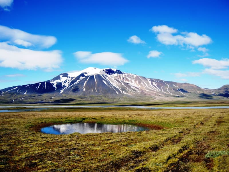
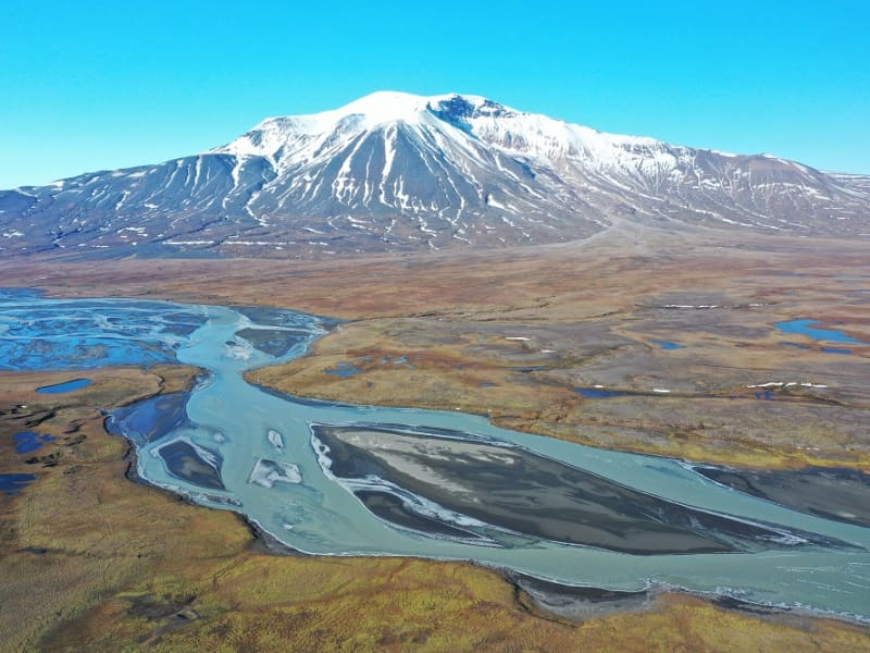
Snæfell
Mt Snæfell towering to 1,833 m, is the highest mountain in Iceland, outside the glacier regions. Even so, and despite the omnipresent snow, (Snæfell = "The Snow Mountain), it is fairly accessible from Snæfellsskáli hut. While Snæfell boasts a splendor of its own, it offers a fabulous view, partly overlooking the oasis of Eyjabakkar. Eyjabakkar is the choice habitat for geese. Reindeer can frequently be spotted west of Snæfell, towards Hálsalón reservoir, in addition to other territories in the East Iceland highlands.
GPX file of the hike is accessible here
View
Hvannargil
Walk from the sign by road F905. A circular trail from Kjólsstaðaskora then Vatnsstæði, inside the lowest Hvannárgil creek through all three creeks to the end of the highest. The highest creek is spectacular and ends in a waterfall. The cylinder with the visitors´log and the stamp is in the highest creek. Walk back down Slórdalur.
GPS: N65°16.868-W15°47.418
Powered by Wikiloc
View
Sótavistir - Hiking trail
A marked hiking trail at the foot of Snæfell where Sótajökull is disappearing from a glacier basin in the mountain called Sótavistir. At the bottom stands a large crag of dark slag rock that the sliding glacier has raised on its end so that it resembles a boulder. It is called Sótaleiði, named after the giant Sóti.
GPX file of the hike accessible here.
View