There are plenty of beautiful waterfalls in Austurland. They are of all shapes and sizes, in diverse scenary which makes many waterfalls exciting to explore. Hiking trails lead to many of them.
Búðarárfoss
A nice and pleasant hike up to Búðarárfoss waterfall. The hike is easy and gives a great view over the town.
Due to a massive landslide in December 2020, the path up to Búðarárfoss waterfall was partially destroyed.
Please treat with caution.
View
Hengifoss í Seldal
Norðfjörður's highest waterfall Hengifoss, is in the river Hengifossá, which flows from Oddsdalur valley into the valley Seldalur. The canyon is exceptionally pretty and lush.
View
Strútsfoss
Start at the sign near Sturluflöt, the innermost farm in Suðurdalur, located east of the Kelduá. From there, walk along the banks of the Fellsá on the eastern side of Villingadalur.
The waterfall cannot be seen until you are quite far into the valley. Once there, you can continue along Strútsgil. Near the creek you will find a cylinder containing a visitors’ logbook and a stamp.
Reaching the waterfall itself requires walking into the creek and crossing the river several times, which can be difficult and potentially dangerous.
Strútsfoss is listed as a protected natural site.
This location is part of Hiking Treasures in the Egilsstaðir Region.
GPS : N64°54.194-W15°02.314
GPX file of the track
View
Gufufoss
Gufufoss waterfall is a beautiful waterfall in Seyðisfjörður. The name is due to the steam emitted by the waterfall and envelops it in a certain mystery. The road over Fjarðaheiði lies next to the waterfall, and the access to it is very good.
View
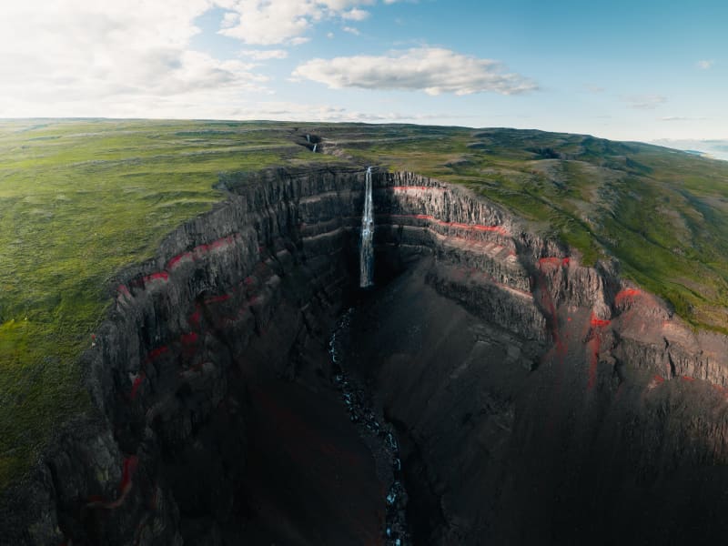
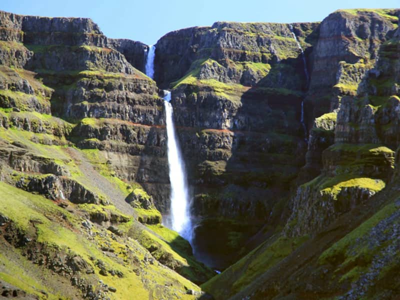
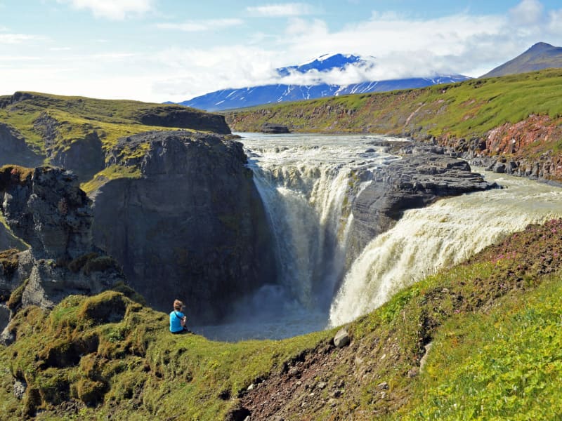
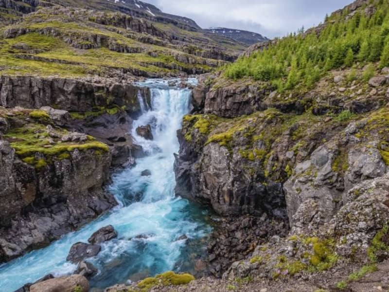
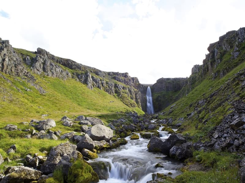
Hengifoss Waterfall
Hengifoss Waterfall is one of the most popular destinations in East Iceland, known for being one of the tallest waterfalls in Iceland at 128 meters high. It is particularly picturesque. A good hiking trail leads you to the waterfall from a service center by the parking lot. Excellent accommodations, restaurants, and activities can be found in the surrounding area.The Hengifoss waterfall plunges from the plateau into a magnificent gorge. The layers between the numerous Tertiary lava strata yield a reddish color, particularly striking in the cliffs around Hengifoss. On the way to Hengifoss, you can also see Litlanesfoss, which features impressive basalt columns on both sides of the gorge.How to Get ThereFrom Egilsstaðir, the major town of East Iceland located by Highway 1, there are two routes to Hengifoss. You can drive on either the west side or the east side of Lake Lagarfljót. The distance is the same, around 35 km.West Side: You will find the junction with Highway 1 on the hill by the timber bridge close to Egilsstaðir airport. It is marked as Route 931 with signs pointing to Fljótsdalur and Skriðuklaustur.East Side: Follow Route 95 first and then Route 931 towards Hallormsstaður, continuing until you reach the end of Lake Lagarfljót. There you should see the waterfall and the parking lot by the main road.From the parking lot, it takes 40-60 minutes to walk to the waterfall on either side of the river. Start by going through a gate by the service center and climbing up a flight of stairs. Then follow a good gravel trail for the next 2 km, which is moderately steep but not very difficult. About halfway up, around 1.2 km from the parking lot, you will see Litlanesfoss with its beautiful basalt columns. There are trails down into the canyon below the waterfall, but they are steep and covered in loose gravel, so be cautious if you decide to enter the canyon. Keep in mind that getting very close to the canyon edge is risky due to the danger of falling. This is especially important if you are accompanied by children.There are two bridges for hikers to connect the trails on each side of the river: one at the upper end just before you enter the great gorge, and the other by the parking lot.By the parking lot is a new service center where you can get information from rangers about the area and the surroundings. We recommend taking your time to visit Hengifoss as there is much more to explore in the area than just the waterfall. You can learn more on this website and use it to help plan your trip.Hiking in SummerDuring the high season (July), Hengifoss can be crowded, mainly with cars at the parking lot. If you can't find a parking space, continue further into the valley and check the visitor's center for Vatnajökull National Park at Skriðuklaustur (5 km away), then return to see if a space has opened up.The waterfall and the gorge face southeast, so for the best lighting, visit in the morning. In June and July, there is usually plenty of water in the river, making Hengifoss magnificent. However, in August, if the summer is really dry, the falls may not be as broad, but they are still enormously high.Late May and early June can be risky due to melting snow in the highlands, causing high water levels in creeks and rivers. Expect muddy trails and slippery paths on your way to the waterfall, and the need to wade through some small streams. By autumn, rain can make the trails muddy as well, but you usually won’t have to wade through any streams unless you want to enter the gorge and get close to the base of the great waterfall.Hiking in WinterMore people are visiting Hengifoss in winter, but caution is necessary. The trails and paths can become icy and very slippery, so stay away from the edge of the canyon and be aware of the dangers. It is not safe to enter the gorge by the big falls in winter due to the risk of falling ice from the cliffs.
Powered by Wikiloc
View
Beljandi
In Breiðdalsá, close to the farm Brekkuborg in Breiðdalur valley, is the Beljandi waterfall. In fact, there are two waterfalls; Ytri Beljandi and Innri Beljandi, and eponymous pools. The waterfalls are not very high, but they are beutiful and well worth the short hike from the road through Breiðdalsvík. The whole area is extremely beautiful and suitable for outdoor activities.
View
Bleiksárfoss waterfall
Bleiksá and its waterfalls are the first thing that catches your eye when you turn off the main road into Eskifjörður.
The highest waterfall in the series of Bleiksár waterfalls is called Bleiksárfoss. Floodlights have been directed up to Bleiksárfoss, and it is quite a spectacle to see it on dark winter evenings, whether it slides down the slope or is covered in ice.
View
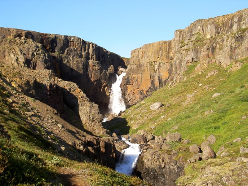
Rjúkandi
Rjúkandi waterfall is a beautiful waterfall that gracefully descends a few cliffs, from the mountains and almost down to highway 1. Access to the waterfall is very good; it is only a short walk from the car park by the main road.
View
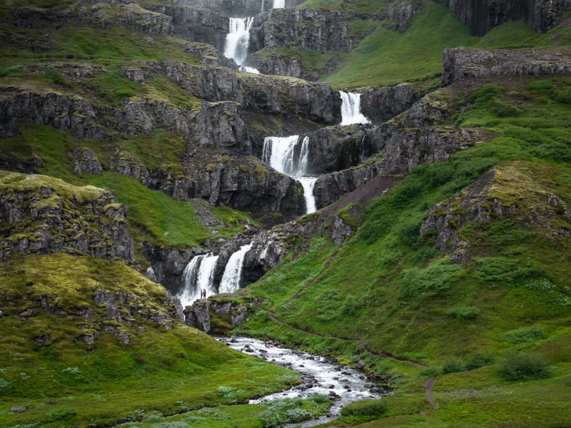
The waterfall trail
The glacial river of the Fljótsdalur valley has many waterfalls of different sizes and shapes, stretching from farms by the edge of the highlands up to the Ramsar protected wetlands of Eyjabakkar. It takes you about 6 hours to walk this 20 km route by the river which in many places runs through a deep canyon. The Wilderness Center is a good starting point and on the way is a natural birch forest, an ideal resting place.
You can expect to see reindeer or maybe an arctic fox. When you reach the plateau it is ideal to drop by the highland hostel at Laugarfell and relax in the natural hot springs. You can also start at Laugarfell and work your way downhill towards the Wilderness Center. The choice is yours. Both Laugarfell and Wilderness Center offer you a drive from one place to the other, before or after the hike.
GPX file of the track
Powered by Wikiloc
View
Flögufoss
Flögufoss is the highest waterfall in Breiðdalur valley, around 60 meters high. The waterfall is in the river Flöguá that runs through the Flöguskarð mountain pass. Just above Flögufoss is another small waterfall that falls to a ledge, from where the river runs under a small rock arch.
The hiking path leading to the waterfall is easy and short.
View
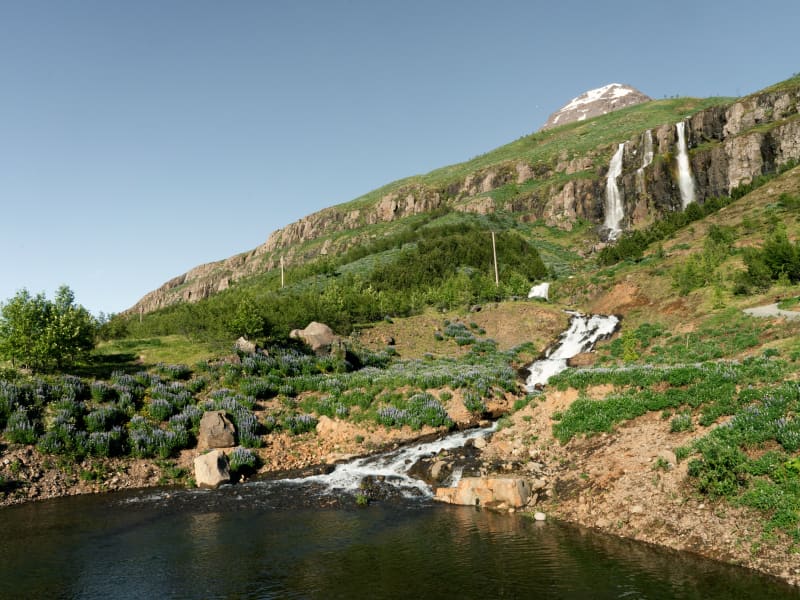
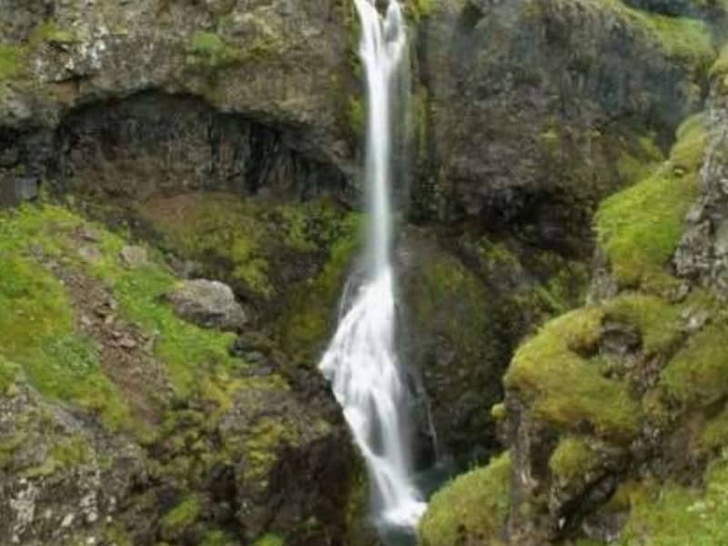
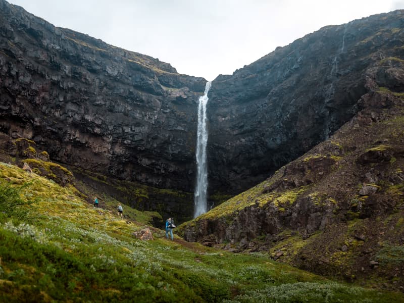
Fardagafoss Hiking Trail
Fardagafoss waterfall is located near Egilsstaðir, at the base of Fjarðarheiði. It is one of three waterfalls on the Miðhúsaá; the others are called Gufufoss and Folaldafoss.
A marked hiking trail leads to the waterfall. The walk is generally easy, except for the final section, which can be a bit challenging to cross. The trail begins at a parking area along Road 93, near the rock known as Áningarsteinn.
Behind the waterfall there is a cave. According to local legend, a fearsome giantess once lived there. It is said that a tunnel runs beneath Fjarðarheiði to Gufufoss in the Fjarðará in Seyðisfjörður.
The giantess of Fardagafoss was said to possess a cauldron filled with gold. When she grew so old that she knew her death was near, she slid the cauldron down into a deep pothole in the middle of Gufufoss, further downstream along the Miðhúsaá River. Legend says that when the water level in the river is low, the handle of the cauldron can sometimes still be seen.
Powered by Wikiloc
View
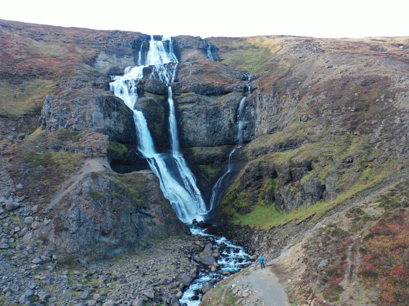
Klifbrekkufossar
Klifbrekkufossar is a magnificent tier of waterfalls in Mjóifjörður. While descending the main road from Egilsstaðir the waterfalls can be spotted on the right-hand side.
View
Sveinsstekksfoss
Sveinsstekksfoss, Fossárfoss eða Nykurhylsfoss
Sveinsstekksfoss waterfall, also known as Fossárfoss waterfall, is a 50-foot waterfall on the Fossá River, the last fall before it empties into the Atlantic Ocean. It is located on Route 1, Northwest of Djúpivogur. You can climb above the waterfall to see more of the Fossá River cascades.
Nykurhylsfoss waterfall is the lowermost waterfall in the Fossá River. The river plunges 15 m into a narrow gully, churning, and racing in pools and rapids until it reaches the 9 m deep Nykurhylur pool.
The river Fossá has numerous waterfalls in its course. There used to be a magical water horse living in the lowest pool, just under the bottommost waterfall. All attempts to drive the water horse away remained unsuccessful, but it finally disappeared when baptismal water was poured into the river after the baptism of a child up the valley.
View
Gljúfursárfoss
The Gljúfursárfoss waterfall, situated on the southern side of Vopnafjörður, runs down a colorful ravine just below the parking lot. The waterfall is about 45 meters high and very beautiful.
The river Gljúfursá used to be a major obstacle to travellers heading east over the mountain pass Hellisheiði eystri. Many accidents occurred when people tried to cross the river by foot or on horseback.
You can also walk along the river to the old bridge over Gljúfursá, built around 1900 and was a great improvement at the time. The story goes that construction began on the bridge after a man on horseback died while attempting to cross the river during winter.
A marked hiking path leads from the parking lot along the river Gljúfursá, and around Drangsnes.
View