Skip to content

Or try searching by Category and/or Location

Top Destinations in Hallormsstaður

Hallormsstaður National Forest
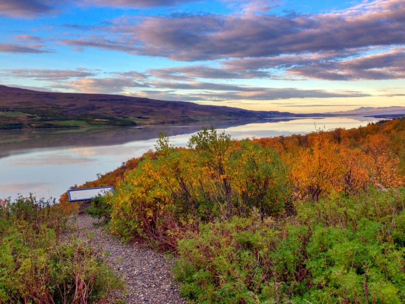
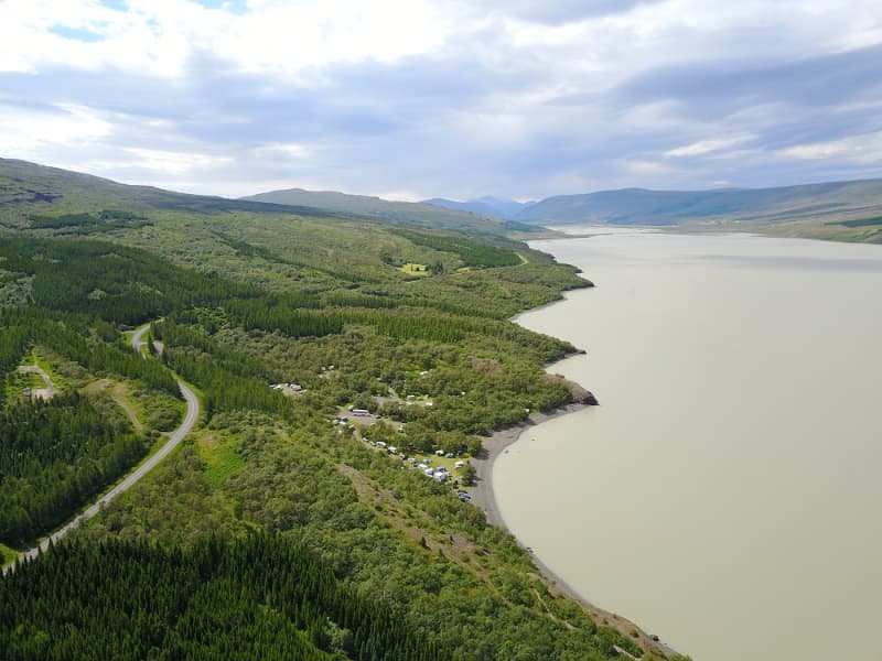
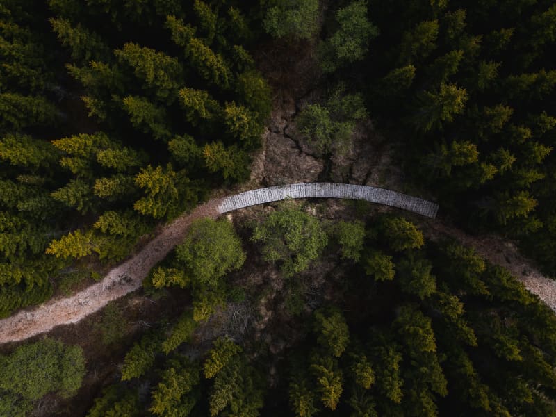
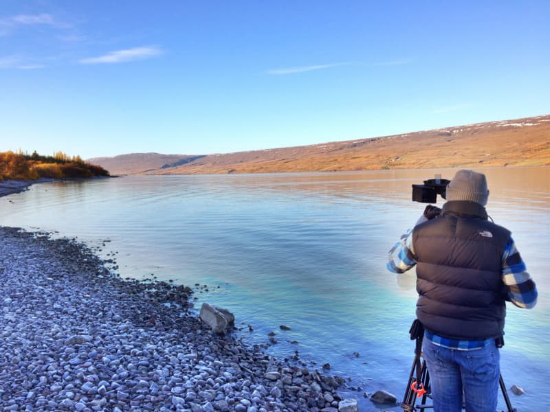
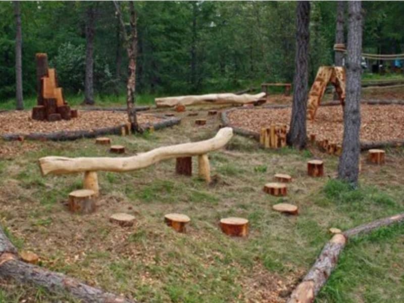
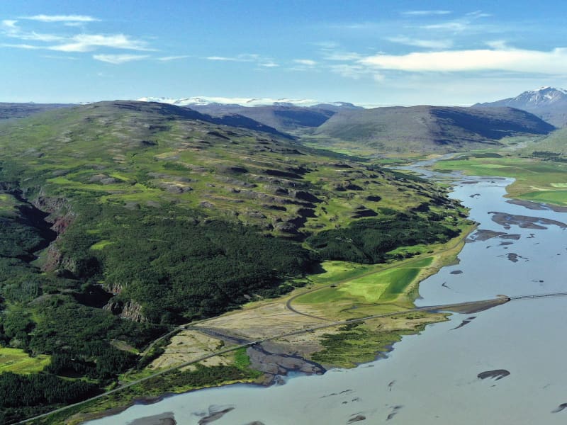
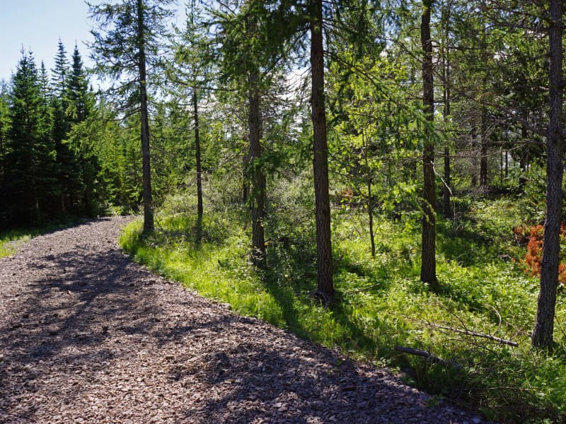
The birchwood remnants at Hallormsstaður farm were protected in 1905, making it Iceland’s first national forest. Today, birch forest and woodland cover about 350 hectares within the original fenced area, and a variety of tree species have been planted on another 200 hectares. Large areas to the north and south have been annexed to the forest more recently and either planted with trees or allowed to naturally regenerate with birch. A total of 85 tree species from over 600 locations worldwide can be found in the forest, covering around 740 hectares.Lands managed by the Land and Forest Service are designated as National Forests. These areas are open to everyone year-round and are located throughout Iceland. Many, like Hallormsstaður Forest, are easily accessible and offer a variety of facilities for outdoor recreation. Others require a 4WD vehicle or hiking up steep hillsides to enjoy.Hallormsstaður Forest is ideal for hiking, strolling, or biking. There are well-marked trails, in different colors, throughout much of the surrounding woodland. These trails are shown on a clear map published by the Forestry Service. The maps can be downloaded HERE.There are two camping sites in the forest: one in Atlavík and the other in Höfðavík. Both sites have small and large flat areas among the trees and are close to Lake Lagarfljót. Foresters will collect the payment for camping. More information can be found on our Facebook page.Rest places and picnic areas are scattered throughout the forest. For example, in Stekkjarvík, there is a barbecue area and a playground. The arboretum in Hallormsstaður is unique in the Arctic region. 
Hallormsstaður
Hallormsstaður is a village situated in the middle of Iceland's oldest national forest. The forest is a popular recreational area featuring camping sites, marked hiking and biking trails, an arboretum, and a frisbee golf course.Hallormsstaður also hosts a large hotel with two restaurants and a spa. Great accommodations, restaurants, and activities can be found in the surrounding area. From Egilsstaðir, the major town of East Iceland located by Route 1, there are two routes to Hallormsstaður. The shortest route, on the east side of Lake Lagarfljót, is 27 km long. For this route, take Road 95 from Egilsstaðir and continue on Road 931 by the Grímsá river. If you choose the west side of the lake, which is 40 km long, you will find the junction with Route 1 on the hill north of the timber bridge near the Egilsstaðir airport. This route is marked as Road 931 with signs pointing to Fljótsdalur and Skriðuklaustur. When you reach the end of the lake, turn left just before reaching Hengifoss waterfall, towards a long bridge, and continue to the forest. 
Atlavík
The inlet of Atlavík camp site in Hallormsstaðaskógur woodland is beautifully situated on the shores of Lake Lagarfljót. In the eighties Icelanders would flock to the legendary Atlavík Festival where no other than Ringo Starr performed in 1984! Like other areas in Hallormsstaðaskógur, the inlet provides the shelter of trees, as well as a comparatively continental climate at the south end of the lake, far away from oceanic conditions. The forest is considered to be Iceland’s largest one. It covers an area of 740 hectares, most of which is native birch. The birchwood remnants at Hallormsstaður were declared protected in 1905.  Hallormsstaðaskógur is a popular outdoor recreational area for both locals and travellers, with its diverse landscapes and over 40 kms of versatile hiking routes and marked trails, open spaces and playgrounds. The Hallormsstaður Arboretum is unique in Iceland, comprising a collection of around 80 tree species from all over the world.    
Arboretum in Hallormsstaðar Forest
The Hallormsstaður Arboretum is unique in Iceland, comprising a collection of around 80 tree species originating from various parts of the world. In addition to trees, there are also various species of shrubs. Begin your walk through the arboretum from the car park by the main road and follow the paths. Allow yourself plenty of time, about 2-3 hours, to explore the arboretum, enjoy the surroundings, and breathe in the fresh air. Walk down to Lake Lagarfljót, enjoy a picnic, and listen to the birds singing.Forestry in Hallormsstaður began in 1903 by fencing off 12 hectares for a tree nursery called Mörk. Half a hectare was prepared as nursery beds, marking the beginning of the nursery. In 1905, 50 Engelmann spruces were planted on the upper half of Mörk. Now, only five of these trees remain, and they are the oldest spruces in the forest, standing close to the parking lot.Over the years, single trees and groups of various species have been planted in Mörk. This arboretum is already the most impressive in the country, offering visitors a good opportunity to see both common and rare species. 
Lagarfljót Wyrm monster
The Lagarfljót is one of Iceland´s deepest lakes and lies in a narrow trough carved by glaciers. It reaches a depth of 112 m, 90 m below sea level and shows no obvious flow. Its deep mysterious glacial waters are the home of Iceland´s ancient and much older equivalent of the Loch Ness monster, the terrifying sea-worm-like Wyrm or "Lagarfljótsormur". The oldest recorded sighting dates back to 1345. At that time the wyrm was said sometimes to resemble large islands, but at other times to rise out of the water in arches, spanning hundreds of fathoms. People were unsure what sort of monster this was, because neither its head nor tail were visible. In 1589, the wyrm was reported to have lifted its back so high above the water that a fast ship under full sail - crosstree, tackling and all - could have passed underneath. When its gigantic body slammed back into the water, the resulting crash rumbled throughout the vicinity. Sightings of the wyrm´s activities were frequent during the next centuries. It appeared variously as humps or islets, and yet again lifted its huge form into the sky. Such appearances were generally considered to bode misfortune. During the 20th century, various shapes of the Lagarfljót Wyrm were viewed from all around the lake. It shot its humps up regularly in addition to appearing as a clump or overturned boat gliding upriver against the current and aginast the wind, tossing towards both sides. A depth sounder once noted it snuggling under an overhanging bank, far below the surface. In February 2012 the farmer at Hrafnkelsstaðir in Fljótsdalur valley cought on camera a large swimming creature in one of the rivers that run into the lake Lagarfljót. The video got over 5 millions hits on Youtube and was in the news around the world. Informatijon boards about the wyrm are located at certain lakeside rest stops. We recommend these stops to check for signs of wyrm activities.
Stekkjarvík
Stekkjarvík is an outdoor area for the family about 4 km away from the urban area of ​​Hallormsstaður, close to Hafursá. There are playground equipment made from local wood, charcoal grills and tables in beautiful clearings.
Valþjófsstaður
Valþjófsstaður is an estate deep in Fljótsdalur. It is an ancient manor, and there has been a church since the thirteenth century. Valþjófsstaður was one of the mainstays of Svínfellingar, but several members of that family were prominent in the conflicts of Sturlungaaldur. The church that now stands in Valþjófsstaður was sanctified in 1966. The door in the inner doorway of the church is a replica of the famous Valþjófsstaður door that Halldór Sigurðsson in Miðhús carved out in the 13th century. The old door was initially used in a manor but was later used as an interior door in an old church that stood in Valþjófsstaður for many centuries. The original door is now in the custody of the National Museum of Iceland.
The Waterfall Circle
The Waterfall Circle is an 8 kilometers long hiking circle that starts and ends in Laugarfell. The trail takes you through a rugged and varied highland landscape and features five waterfalls, along with breathtaking views of Snæfell mountain and a dramatic canyon. This beautiful hike is getting more and more popular among hikers and takes around 2–3 hours to complete, depending on conditions and pace. While it’s not overly difficult, there are a few steep and rocky sections, so sturdy footwear is recommended. After the hike, you can soak your tired legs in Laugarfell’s natural hot spring. This trail is typically accessible from mid-June once snow has melted in the highlands. GPX file of the track Powered by Wikiloc
Þjófadalur (Thief valley)
Þjófadalur is a beautiful valley that lies south of Snæfell. To get there you have to walk, the best is to walk along the Þjófadalsá river through Þjófadalur between Snæfell and Þjófahnjúkar. The valley is beautiful and accessibility is only good as summer passes. If you walk east into the valley, there is a very good view of Eyjabakki and Þóriseyjar.
Hrafnkels saga trail
Hrafnkell's Saga Freysgoði is set in East Iceland and tells the story of conflicts between chieftains in the 10th century. Hrafnkell’s farm in Fljótsdalur is named after Hrafnkell, who lived there for a period. Not far from the town, you can find a historical sign marking part of a heritage trail that leads across Fljótsdalsheiði and down into Hrafnkelsdalur, allowing visitors to follow in the footsteps of the saga’s characters. 
Ranaskógur woods
Often considered one of the country´s most beautiful birch woods, Ranaskógur has numerous birches with white bark and tall, straight trunks. Moreover, the forest floor is unusually smooth, in comparison to most Icelandic wooded areas. In the Icelandic name, skógur means "woods" and rana refers to the lower end of the long ridge west of the Gilsá river gorge. Ranaskógur extends along the west side of the gorge, which is the traditional border between two counties in East Iceland. The Icelandic birch species is Betula pubescens. Besides the abundant wood crane´s bill, Geranium sylvaticum, and stone bramble berry plants, Rubus saxatilis, in the undergrowth, Ranaskógur has an unusual number of tall rowan trees, Sorbus aucuparia; in fact, no other Icelandic site presents such a concentration of large rowans.  At the Kiðuhóll rise in the middle of Ranaskógur, Metúsalem J. Kjerúlf, farmer at the nearby Hrafnkelsstaðir, started a plot of coniferous trees between 1955 and 1961, in remembrance of his brother Páll. Not only did Metúsalem plant 23 different species, but 21 are still represented, with the talles trees nearing a height of 20 m. The Ranaskógur woods have existed ever since Iceland´s settlement and are mentioned in documents from the 15th century. hey are part of the woods which figured in the well-known Saga of Hrafnkell, which states that the saga´s hero cut down stands of trees here when he moved to this valley and built up the farm that has since been named after him, Hrafnkelsstaðir. Nineteenth-century quarrels between the Hrafnkelsstaðir and Víðivellir farmers over the use of forest resources resulted in most of the lower part of the woods being cut down. While the woods had previously extended south below Kirkjuhamar cliff, now only a very few of those trees remain, at a place called Skógarbali.  The traditional use of Ranaskógur for firewood continued until nearly the middle of the 20th century, and in 1951 Eiríkur M. Kjerúlf bought the woods to make them part of a new farm, Vallholt.
Hrakstrandarkofi
Hrakstrandarkofi is a newly renovated pedestrian hut on the hiking trail between Norður and Suðurdalur. You can walk intoNorðurdalur past Glúmstaðarsel and into Hrakströnd, and then the next day across to Þorgerðstaðardalur and on to Suðurdalur. Bookins for the hut are made at The Wilderness Centre .  
Mulakollur
Þingmúli divides Skriðdalur into Norðurdalur and Suðurdalur. The Round Road nr.1 lies through Suðurdalur to Breiðdalur. The homestead at Þingmúli was a place of gathering for the Thing in Eastern Iceland for centuries. The northernmost part of the mountain is called Múlakollur. Walk the ridge from the sign straight up to 400 m. When you reach Múlakollur’s top it is pleasant to walk onwards and along the top and descend on the east side a bit south of Múlastekkur. One can also ascend by walking up from Múlastekkur. Part of Hiking Treasures in Egilsstaðir Region GPS : N65°01.624-W14°38.049 Powered by Wikiloc